Best GPS Devices Every Trucker Relies On for Every Mile
You rely on GPS devices built for the long haul, like the Garmin dēzl OTR1000 with its 10-inch rotatable display and 1280 x 800 resolution for sharp, sunlight-visible maps. These units deliver truck-specific routing based on height, weight, HazMat status, and axle count, avoiding low bridges and restricted roads. Real-time alerts for weather, traffic, and weigh stations come via Bluetooth and smartphone pairing. Preloaded North America maps get lifetime updates every 3–6 months. A deeper look reveals even more advantages.
We are supported by our audience. When you purchase through links on our site, we may earn an affiliate commission, at no extra cost for you. Learn more. Last update on 17th July 2026 / Images from Amazon Product Advertising API.
Notable Insights
- Large 7- to 10-inch high-resolution touchscreens with anti-glare coating ensure clear visibility in sunlight and during night driving.
- Custom truck routing avoids low bridges, weight-restricted roads, and hazardous terrain based on vehicle size, weight, and HazMat status.
- Lifetime free map updates every 3–6 months keep routes accurate across North America, including the U.S., Canada, Mexico, and Caribbean.
- Bluetooth connectivity enables real-time alerts for traffic, weather, weigh station bypasses, and smart notifications via smartphone pairing.
- Dedicated truck-specific features include programmable stops, crowd-sourced parking data, and enhanced views for loading docks and rest areas.
Garmin dezl OTR710 7″ GPS Truck Navigator

If you’re a long-haul trucker who needs a reliable, feature-rich GPS built for the road, the Garmin dezl OTR710 7″ GPS Truck Navigator is built with you in mind. I rely on its 6.95-inch high-res touchscreen for clear, bright visuals, even in direct sunlight. Measuring 7 x 0.8 x 4.2 inches and weighing just 8.5 ounces, it fits neatly in any cab. It uses custom truck routing based on your vehicle’s size and weight, alerting me to bridge heights, steep grades, and sharp curves. BirdsEye Satellite Imagery helps me spot loading docks easily. With Bluetooth, I get live traffic, weather, and smart notifications via the dēzl app.
Best For: Long-haul truck drivers who need a reliable, large-screen GPS with custom routing, real-time smart notifications, and advanced trucking-specific features.
Pros:
- Large 7-inch high-resolution touchscreen provides clear visibility even in direct sunlight
- Custom truck routing with alerts for bridge heights, weight limits, sharp curves, and steep grades enhances safety and efficiency
- Bluetooth connectivity enables live traffic, weather, and smart notifications via the dēzl app, plus support for PrePass and service point tracking
Cons:
- Limited 2-hour battery life makes it unsuitable for use without constant power in the truck
- 90-day warranty is shorter than some competitors offer for similar devices
- Renewed model may raise concerns about long-term durability and resale value
Garmin dezl OTR610 6″ GPS Truck Navigator

The Garmin dezl OTR610 6″ GPS Truck Navigator delivers specialized routing and extensive trucking features tailored for over-the-road professionals hauling large or heavy loads. Its 6-inch high-resolution touchscreen stays bright and crisp, even in direct sunlight. I rely on custom truck routing based on my vehicle’s height, weight, and cargo type. It alerts me to low bridges, steep grades, and sharp curves, though I always confirm with posted signs. The device includes lifetime map updates across North America and uses Bluetooth to connect to my smartphone and the dēzl app. I access PrePass notifications, live traffic, and truck-specific stops like Love’s.
Best For: Over-the-road truckers hauling large or heavy loads who need reliable, truck-specific routing and real-time connectivity.
Pros:
- Provides custom truck routing based on vehicle dimensions and weight, with critical alerts for bridges, curves, and grades
- Includes lifetime map updates for North America and integrates with PrePass, live traffic, and the dēzl app via Bluetooth
- Offers large 6-inch high-resolution touchscreen with excellent visibility in direct sunlight and supports key trucking accessories
Cons:
- Route suggestions may not account for all vehicle-specific restrictions in every region
- Some advanced features require a paired smartphone and active subscriptions
- Limited to North American map coverage, with no support for routing outside the region
Garmin dezl OTR720 7″ GPS Navigator
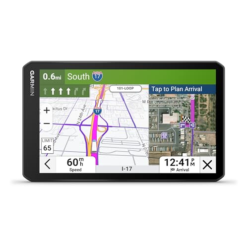
When long-haul precision and real-time decision support matter most, the Garmin dezl OTR720 stands out for professional over-the-road truckers. Its 7-inch high-resolution touchscreen delivers clear, bright visuals, even in direct sunlight. I rely on custom truck routing that accounts for my rig’s height, weight, and length to avoid hazards like low bridges and sharp curves. Real-time PrePass notifications help me bypass weigh stations seamlessly when paired with my smartphone via Bluetooth. The unit overlays wind speed data on the map, alerting me to dangerous conditions. BirdsEye Satellite Imagery gives me aerial views of destinations, improving arrival planning. I access community-shared parking, docks, and gates, plus rate spots myself through the dēzl app.
Best For: Long-haul truckers who need advanced navigation, real-time alerts, and community-driven trucking resources for safer and more efficient over-the-road operations.
Pros:
- Large 7-inch high-resolution touchscreen offers excellent visibility and easy use in bright sunlight
- Custom truck routing and safety alerts based on vehicle dimensions help avoid hazardous roads and infrastructure
- Integration with PrePass, BirdsEye Satellite Imagery, and community parking data enhances arrival planning and efficiency
Cons:
- Requires a compatible smartphone and dēzl app pairing for full feature access, such as wind alerts and parking contributions
- Subscription or active account needed for PrePass weigh station bypass functionality
- High initial cost may be a barrier for owner-operators on a tight budget
Truck GPS Navigator 9″ with Lifetime Updates

You’ll want this 9-inch Truck GPS Navigator if you’re a long-haul trucker who relies on accurate, up-to-date maps and truck-specific routing. It comes preloaded with 2026 North America maps covering the U.S., Canada, and Mexico. You get free lifetime map updates-just connect to a Windows PC or use a TF card. Mac isn’t supported. The 9-inch 800×480 touchscreen delivers clear 2D and 3D views, optimized for readability in harsh lighting. It alerts you to bridge heights, sharp curves, weight limits, and more. You can set routes by truck size, weight, and class. It supports Truck, Bus, Ambulance, and other vehicle modes. Voice guidance works in over 40 languages. FM transmission sends directions through your radio. Alerts include speed changes, traffic lights, and animal crossings. A U.S.-based support team backs the device. Charge fully before first use. Best signal locks outdoors.
Best For: Long-haul truckers needing reliable, truck-specific routing and lifetime map updates across North America.
Pros:
- Preloaded with 2026 North America maps and supports free lifetime updates via Windows PC or TF card
- Customizable truck routing with alerts for bridge heights, weight limits, sharp curves, and other hazards
- Large 9-inch touchscreen with 2D/3D views and FM transmission for clear, hands-free voice guidance in over 40 languages
Cons:
- Map updates only compatible with Windows PCs, not Mac
- Requires outdoor signal acquisition for optimal GPS lock
- Limited to 800×480 screen resolution, which may appear low by modern display standards
Garmin dēzl OTR620 6” GPS Truck Navigator

Garmin builds the dēzl OTR620 for long-haul professionals who demand precision and real-time adaptability on cross-country routes. I rely on its 6-inch high-resolution touchscreen for clear visibility in any light. It calculates custom truck routing using my height, weight, and hazmat status. I get alerts for bridge clearances, steep grades, and sharp curves-vital for avoiding costly mistakes. BirdsEye Satellite Imagery helps me pinpoint loading docks and truck entrances. I find trusted parking with community ratings and access PrePass weigh station bypasses via Bluetooth. Wind speed overlays warn of hazardous conditions. I use the truck-specific directory for breaks, fuel, and CAT Scales across the U.S. and Canada.
Best For: Long-haul truck drivers who need precise, customizable routing and real-time safety alerts for cross-country freight operations.
Pros:
- Custom truck routing based on vehicle dimensions and hazardous materials for safer, more efficient travel
- Community-rated truck parking, PrePass integration, and searchable truck services enhance on-the-go planning
- Wind speed weather overlays and BirdsEye Satellite Imagery provide critical situational awareness at loading zones and on routes
Cons:
- Requires a smartphone and active PrePass account for full connectivity features like weigh station bypass alerts
- High-resolution satellite imagery and real-time data rely on app connectivity, limiting functionality without a paired device
- Larger touchscreen may be cumbersome in smaller cabs or with limited dashboard mounting options
Truck GPS Navigator with Lifetime Updates

If you’re a professional trucker needing reliable, up-to-date routing across North America, this 7-inch truck GPS navigator delivers precision and long-term value with free lifetime map updates. It comes preloaded with 2026 maps covering the USA, Canada, and Mexico. Updates are handled by LOVPOI’s U.S.-based tech team, guaranteeing accuracy. The 7-inch display offers 2D and 3D views with automatic day/night mode. I get turn-by-turn voice guidance in over 40 languages, including alerts for curves, speed changes, and hazards. I can input routes by address, postal code, coordinates, or POI. It supports car, truck, bus, taxi, and emergency vehicle modes. Truck-specific routing accounts for height, weight, and load restrictions. Real-time data shows distance, speed, and estimated arrival. I rely on its FM transmitter for audio routing through my cab’s sound system. Outdoor use guarantees strong satellite signal. I always fully charge it before first use.
Best For: Professional truckers and commercial drivers who need accurate, up-to-date routing across North America with long-term map update support.
Pros:
- Preloaded with 2026 North America maps and includes free lifetime map updates managed by a U.S.-based technical team
- Offers truck-specific routing with alerts for bridge heights, weight limits, and hazardous road conditions
- Supports multiple vehicle types and provides turn-by-turn voice guidance in over 40 languages with FM transmitter audio output
Cons:
- FM transmitter is included but not a full FM radio, limiting audio functionality
- Requires outdoor use for optimal GPS signal, which may delay initial setup in enclosed spaces
- No mention of real-time traffic updates or advanced driver assistance features like lane guidance or speed limit signs
Rand McNally 7″ GPS Truck Navigator

The Rand McNally 7″ GPS Truck Navigator stands out for professional over-the-road and regional haulers who demand precision in route planning and compliance. It features an 8-inch crisp, bright touchscreen powered by Rand Road IQ and Rand Navigation 2.0 software with 2025-edition maps. I input my rig’s specs-height, weight, axles (2–15), trailer type, and HazMat class-for exact truck-specific routing. Real-time traffic, weather, fuel prices, and speed camera alerts keep me informed. It warns of curves, hills, weigh stations, and engine brake zones. The durable design includes dual power via USB-C and barrel connector, a strong magnetic mount, built-in camera, and POIs for parking, scales, and rest areas.
Best For: Professional truck drivers needing precise, compliance-friendly routing based on detailed vehicle and cargo specifications.
Pros:
- Delivers accurate truck-specific routing using customizable inputs like weight, height, axles, trailer type, and HazMat classification
- Offers real-time updates on traffic, weather, fuel prices, and road alerts including speed cameras and weigh stations
- Features a durable design with dual-power options, strong magnetic mount, and built-in camera for practical fleet use
Cons:
- Slight touchscreen lag reported when navigating complex menus or rendering detailed maps
- Limited app integration compared to smartphone-based solutions
- Camera quality is functional but not high-resolution, best suited for documentation rather than clarity
9″ GPS Navigator for Car & Truck

This 9-inch GPS Navigator for Car & Truck is built for professionals who demand clarity, precision, and reliability on long-haul routes. The 9-inch touchscreen gives me 30% more viewing area than standard 7-inch models, improving map visibility. It switches automatically between day and night modes and supports 2D/3D map views. Preloaded North America maps cover the U.S., Canada, and Mexico through 2026, with lifetime free updates and EU/UK downloads available. It calculates routing based on my vehicle’s height, width, and weight-perfect for trucks, RVs, or vans. Safety alerts warn me about speed zones, sharp curves, and restricted roads.
Best For: Professional drivers and frequent travelers who need a large, reliable GPS with vehicle-specific routing and extensive map coverage for cars, trucks, RVs, and vans across North America.
Pros:
- 9-inch touchscreen offers 30% more display area than 7-inch models for better visibility and ease of use
- Preloaded North America maps with lifetime free updates and support for EU/UK downloads
- Smart routing and safety alerts tailored to vehicle size, including warnings for restricted roads, speed zones, and sharp curves
Cons:
- No voice command functionality, limiting hands-free operation
- Powered by a single 12V battery which may limit portability or backup use
- Larger screen and dashboard mount may obstruct view in smaller vehicles if not positioned carefully
OHREX N900 9″ GPS Navigator for Trucks

You’re a professional trucker who demands accuracy, durability, and no-nonsense navigation tailored to large commercial vehicles-this OHREX N900 9″ GPS Navigator is built for you. It comes with 2026 North America maps and lifetime free updates via SD card-no subscription or SIM needed. The 9-inch touchscreen delivers crisp 800 x 480 resolution, supports 2D/3D maps, and works in cars or semi-trucks. It calculates custom routes using your truck’s height, weight, and load type, warning you about low bridges, sharp curves, and weight restrictions. You get real voice guidance in over 40 languages and FM transmission to your stereo. Support is U.S.-based.
Best For: Professional truck drivers and commercial vehicle operators who need reliable, large-screen navigation with truck-specific routing and lifetime map updates.
Pros:
- Offers lifetime free map updates via SD card with no subscription or SIM card required
- Features custom truck routing with alerts for bridge heights, weight limits, and hazardous road conditions
- Includes real voice guidance in over 40 languages and FM transmission for seamless audio integration
Cons:
- Map updates require a Windows PC; not compatible with Mac systems
- Satellite signal acquisition may be slow and requires outdoor use for initial setup
- Limited regional map availability outside North America without special request
Garmin dēzl OTR1000 10-inch GPS Truck Navigator

Need a GPS that handles the long haul with precision? I rely on the Garmin dēzl OTR1000. Its 10-inch display delivers crisp 1280 x 800 resolution, readable in landscape or portrait. The touchscreen stays responsive in all conditions. I use voice commands to keep my hands on the wheel. It provides load-to-dock guidance and custom routing based on my truck’s height, weight, and length. I get alerts for bridge clearances, steep grades, and sharp curves. Truck-specific parking and Trailer Services appear along my route. It mounts多种 ways and works with a Garmin eLog ELD. Renewed units look and function like new, include a 90-day warranty, and weigh just 1.18 pounds.
Best For: Long-haul truckers who need a reliable, large-display GPS with truck-specific routing, voice control, and real-time alerts tailored to their vehicle’s dimensions and load.
Pros:
- 10-inch high-resolution touchscreen with landscape/portrait flexibility for clear, easy viewing
- Custom truck routing with alerts for bridges, weight limits, curves, and steep grades enhances safety and compliance
- Supports voice commands and integrates with Garmin eLog ELD for hands-free use and seamless HOS logging
Cons:
- Only up to 2 hours of battery life, limiting use without constant power connection
- Renewed units available but may concern some buyers despite being tested and warranted
- Advanced features like ELD require separate purchase, increasing overall cost
Factors to Consider When Choosing GPS Truckers
You need a GPS that works as hard as you do, starting with a display size and clarity that lets you see key details at a glance. Look for screens at least 5 inches with high-resolution (800×480 or better) displays and anti-glare coatings-critical for daytime visibility. These features, combined with routing accuracy and customization for truck-specific restrictions like height, weight, and hazardous road types, guarantee you stay on time and compliant.
Display Size And Clarity
A clear, well-sized display is essential for quick decision-making on the road. A 9-inch screen gives you about 30% more viewing area than a 7-inch model, making maps and alerts easier to see at a glance. Larger displays reduce eye strain during long-haul drives, especially with high-resolution touchscreens. Look for models with at least 800×480 pixels-this guarantees sharp graphics and legible text. Bright, crisp outputs stay visible in direct sunlight, so you won’t miss critical turns. Touch responsiveness should be accurate, allowing safe fingertip use without distraction. Automatic day/night mode adjusts brightness and contrast based on lighting, cutting glare in dark conditions. Landscape or portrait orientation options help optimize dashboard space and sightlines. These features work together to enhance clarity, letting you focus on the road ahead without squinting or second-guessing.
Routing Accuracy And Customization
While generic GPS systems may guide passenger vehicles accurately, truck-specific routing is essential for avoiding costly and dangerous misroutes. Your GPS must account for your rig’s height, weight, and axle count to bypass low bridges, narrow roads, and weight-restricted routes. Custom systems alert you to hazardous conditions like steep grades or sharp curves unsuitable for large vehicles. Real-time data and satellite imagery help pinpoint ideal access to loading docks and secure truck entrances. Advanced models let you program stops for fuel, rest breaks, parking, and scaling based on your truck’s needs. Routing improves with community-shared insights-thousands of drivers validate common paths, parking spots, and entry points. These crowd-sourced updates enhance accuracy. Look for systems using live truck-verified data feeds and support for configurable vehicle profiles. Precision routing reduces delays, fines, and risk. It’s not just navigation-it’s operational efficiency built into every mile.
Battery Life And Power Options
Since extended hauls demand uninterrupted navigation, battery life and power management in truck GPS devices play a critical role in maintaining reliable performance. Most units offer 2 to 3 hours of battery life, limiting standalone use without vehicle charging. You’ll rely on continuous power via 12V car charger or USB connection to keep the device running. Internal batteries aren’t user-replaceable, so long-term reliability depends on efficient charging cycles. Dual power models let you switch seamlessly between battery backup and direct power, minimizing downtime. Low-power modes and auto-shutdown features help preserve energy during inactivity. Think of the battery as a backup-not the primary source. Prioritize devices with robust power management, ensuring your GPS stays active through engine restarts or detours without missing a beat.
Voice Guidance And Audio Quality
You depend on your GPS to stay focused on the road, not fumbling with unclear directions. Clear voice guidance delivers natural-sounding speech with adjustable volume, guaranteeing you hear instructions over engine and road noise. Look for systems with built-in amplification and noise-filtering tech-these maintain audio clarity during windy or rainy stretches. Multi-language support with accurate pronunciation helps when crossing borders or driving through diverse regions. Some models offer FM transmission, broadcasting turn-by-turn alerts through your truck’s stereo for seamless integration. Audio cues include upcoming speed changes, sharp curves, and road hazards, reducing screen glances. High-end units process speech faster, minimizing lag between instruction and action. Crisp audio doesn’t just help-it protects. Choose a device with at least 3.5mm jack support and digital signal processing to guarantee every command cuts through the cab’s background din.
Truck Specific Safety Alerts
When traversing complex road networks, your GPS becomes a critical safety partner by delivering truck-specific alerts tailored to your vehicle’s dimensions and operating conditions. It warns you of low bridges, weight-restricted roads, sharp curves, steep grades, and railroad crossings-preventing costly damage and accidents. Alerts activate based on your input: height, length, weight, and hazardous material status. Advanced systems add engine brake zones, narrow roads, construction areas, and high-wind warnings, improving situational awareness. You’ll get real-time speed change notifications, animal crossings, and red light camera alerts designed for commercial operations. Visual icons and audible voice prompts deliver warnings clearly without distraction. The system uses precise geofencing and road attribute databases to guarantee accuracy. Alerts trigger at ideal distances-typically 500 feet or more-giving you time to react. These features aren’t just helpful; they’re essential for compliance and safety. Choose a GPS with robust, customizable alert settings to match your fleet’s operational profile.
Map Updates And Coverage
How often are your maps updated-and do they cover every route you drive? Choose GPS devices with free lifetime map updates to maintain accuracy without extra costs. Regular updates reflect new road constructions, closures, truck route changes, and revised regulatory restrictions. Preloaded maps must include full coverage of North America-especially Canada, Mexico, and the Caribbean-if you travel internationally. High-quality map data includes truck-specific details like bridge heights, weight limits, and approved truck parking locations. Updates should install easily via PC connection or SD card; note that some models aren’t Mac-compatible. Reliable map systems refresh every three to six months, ensuring current route intelligence. Don’t rely on outdated topography-your routing efficiency depends on current, extensive cartography designed for commercial vehicles. Consistent map accuracy reduces detours, saves fuel, and keeps you compliant on every haul.
Connectivity And Smart Features
Modern GPS devices for truckers go beyond basic navigation by integrating connectivity and smart features that enhance situational awareness and streamline operations. You’ll use Bluetooth to pair your smartphone, pulling live traffic, weather alerts, and notifications directly onto the screen. Units like the Rand McNally TND 560 sync with companion apps, delivering crowd-sourced data on truck parking and road conditions in real time. PrePass support requires both a Bluetooth link and active account, automatically sending weigh station bypass alerts based on GPS location and credentials. Satellite imagery integration provides high-res aerial views, showing loading docks, security gates, and rear entrances for improved arrival planning. You can expand functionality by connecting backup cameras, headsets, or smartwatches for hands-free control. These features rely on stable 2.4 GHz Bluetooth 4.0+ and compatible iOS or Android devices. Reliable connectivity guarantees safer, more efficient routing and reduces downtime with actionable intelligence.
Frequently Asked Questions
Can I Use Truck GPS for Personal Cars?
Yes, you can use a truck GPS in a personal car, but it’s not ideal. Truck GPS units calculate routes based on vehicle size, weight, and cargo type, which may lead to unnecessary detours for smaller vehicles. They often avoid roads with low clearance or weight limits irrelevant to cars. While functional, personal car navigation systems offer faster routing, better traffic updates, and more points of interest tailored to everyday drivers.
Are Truck GPS Devices Waterproof?
Yes, most truck GPS devices are water-resistant, not fully waterproof. You’ll find them rated IPX7 or similar, meaning they withstand splashes and brief immersion. They handle rain, humidity, and spills but aren’t built for submersion. Sealed casings and rubberized ports protect internal circuits. For wet environments, this level keeps performance reliable. Always check manufacturer specs-some models exceed basic protection. Don’t assume all units endure prolonged water exposure.
Do Truck GPS Units Work Internationally?
Yes, most truck GPS units work internationally, but with limitations. You’ll need a model supporting global satellite networks like GPS, GLONASS, or Galileo. Many truck-specific units come preloaded with North American maps only. You must manually install regional map updates for Europe, Asia, or Australia. Check device specs-some Garmin and Rand McNally models offer multi-region options. Guarantee firmware supports international routing for truck dimensions, weight, and hazardous cargo.
How Often Are Map Updates Released?
Map updates release every quarter, usually every 90 days. Manufacturers push updates to guarantee routing accuracy and regulatory compliance. You’ll get new road layouts, construction zones, and changed speed limits. Most devices auto-download via Wi-Fi when connected. Some models offer over-the-air (OTA) updates using embedded cellular. Storage needs 4–8 GB free space. Frequent updates prevent costly delays. Think of it like software patches-skipping them risks outdated data. Always confirm your model’s update cycle.
Can I Add Custom Waypoints to Routes?
Yes, you can add custom waypoints to your route. Most truck-specific GPS units let you input multiple stops manually using latitude and longitude or address entry. Devices support up to 50 or more waypoints depending on model memory. You maintain control over stop order, with options to resequence waypoints dynamically. Routing algorithms adjust for truck dimensions, weight, and hazardous road restrictions when calculating path changes. This guarantees compliant, efficient navigation across long-haul journeys.